
By Brandon Smith, CFM, Mitigation Specialist at Goodwyn Mills Cawood
In 2020, the Town of Dauphin Island, Alabama found itself facing a tough reality. Just weeks apart, the 14-mile coastal barrier island was hit with two hurricanes, leaving behind widespread damage, flooding and a long list of recovery challenges. What followed was a community-wide effort to come back stronger, more organized and better prepared for the future.
Through a combination of technical expertise, local commitment and persistence, Dauphin Island not only achieved full compliance with federal floodplain requirements but also improved its Community Rating System (CRS) classification, enhancing community resilience and reducing flood insurance premiums for its residents.
When Hurricane Sally hit in September 2020, Dauphin Island recorded sustained winds of 80 mph with wind gusts over 100 mph. Over 9.6 inches of rainfall created the third-highest water level in the region at 3.1 feet. Due to the winds and torrential rain, there was substantial damage to homes and buildings, as well as flooding on the West End.
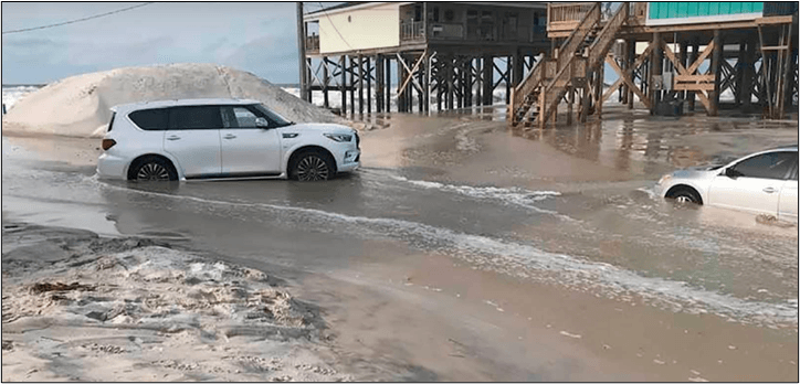
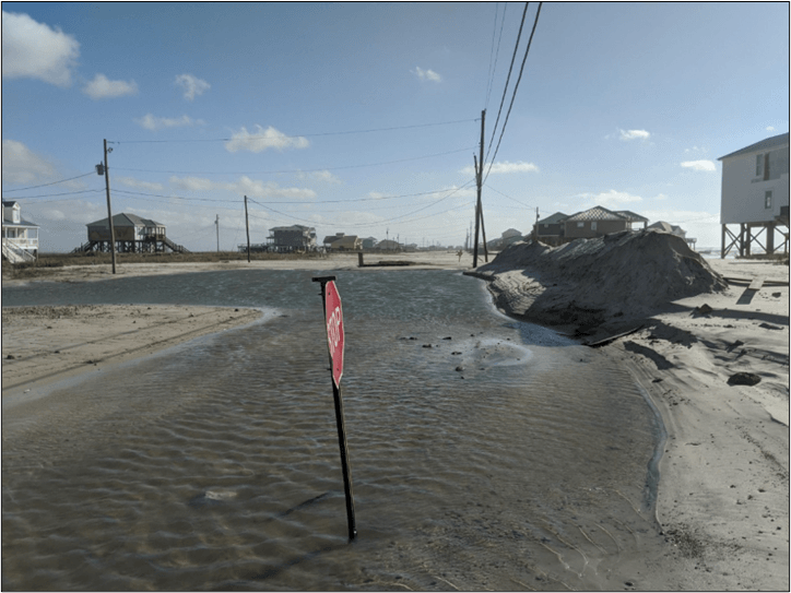
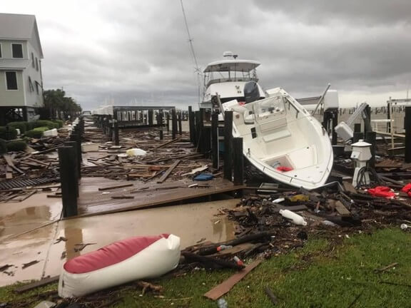
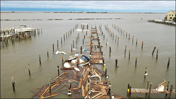
Just one month later, the community experienced a second major storm event. Hurricane Zeta came through the Gulf in October 2020 and the town faced flooding again. Flood waters caused damage to homes and buildings, pushing sand and saltwater onto the main thoroughfare, Bienville Boulevard. The aftermath made the West End of Dauphin Island completely impassable, with downed power lines and debris at every turn. A recreational fishing boat had even been pushed onto the local airport. These back-to-back storm events exposed vulnerabilities in the town’s floodplain management practices and underscored the need for a more structured, compliant and resilient approach moving forward.
In early 2021, following the severe impacts of the 2020 hurricanes, FEMA conducted a Community Assistance Visit (CAV). A CAV is a comprehensive assessment conducted by FEMA or state partners to evaluate a community’s floodplain management program, ensure compliance with National Flood Insurance Program (NFIP) regulations and provide technical assistance to local officials.
Due to the passage of time and the impacts of recent storm damage, FEMA identified several non-compliance issues within the community. These included incomplete or missing construction and elevation documentation; inconsistent or inaccessible historical records; and structural deficiencies such as inadequate flood vents, non-compliant breakaway stairs and gaps in substantial damage assessments.
As Dauphin Island’s consulting partner, GMC supported the town in navigating this critical phase by coordinating efforts across key functional areas, including the environmental department and the disaster recovery department. To address these findings, GMC worked with town staff to develop a detailed Corrective Action Plan (CAP), establishing a clear framework for achieving compliance across the island.
A key component of this effort was the creation of a geodatabase designed to capture and organize the most up-to-date compliance documentation. As the town addressed identified issues, each property was tracked through color-coded mapping, providing a clear visual of progress. This tool enabled town officials to efficiently monitor completed work, identify remaining gaps and maintain organized, accessible records throughout the process.
Building on this system, field assessments were conducted using the developed geodatabase and ArcGIS Field Maps to evaluate site-specific compliance issues. These assessments focused on identifying deficiencies such as inadequate flood venting; non-compliant breakaway walls and staircases; the presence of storage or living space below the Base Flood Elevation (BFE); improper floor drains; and improperly elevated mechanical equipment. The resulting data was compiled and submitted to FEMA, with a target of achieving greater than 90% compliance. Throughout this process, the community remained engaged and property owners demonstrated a strong willingness to implement the necessary corrective measures.
As violations were addressed across individual properties, Dauphin Island made steady progress toward its goal of achieving greater than 90% compliance. At the same time, the town aimed to not only meet FEMA requirements but also improve its Community Rating System (CRS) classification.
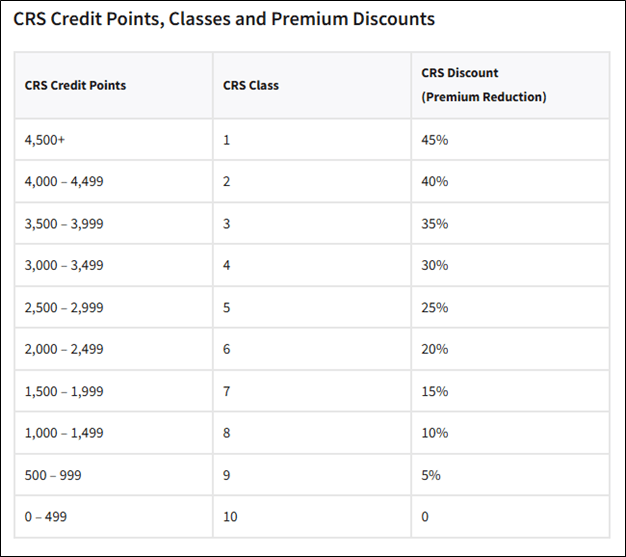
The CRS, administered by FEMA, encourages communities to implement proactive floodplain management practices that go beyond minimum NFIP requirements. Communities are assigned a classification ranging from Class 10 (no discount) to Class 1 (highest level of achievement), with each improvement in class resulting in greater flood insurance premium discounts for policyholders. As a community’s rating improves, residents benefit from increased savings, with discounts ranging from 5% to 45%.
In addition to addressing immediate compliance gaps, the town implemented several strategic initiatives to strengthen long-term resilience and improve its CRS standing. GMC worked with Dauphin Island to develop its first Substantial Damage Management Planning (SDP). The SDP establishes a clear, standardized process for evaluating and documenting damage to structures following a disaster, ensuring that substantial damage determinations are conducted consistently and in accordance with NFIP requirements. By proactively defining roles, procedures and documentation methods, the plan enables Dauphin Island to respond more efficiently after future events, maintain compliance and support informed rebuilding decisions that reduce long-term flood risk.
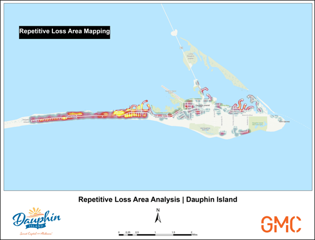
In addition to the SDP, GMC conducted a comprehensive Repetitive Loss Area Analysis (RLAA) to support the town’s CRS improvement efforts. An RLAA is a detailed evaluation of structures that have experienced repeated flood losses, focusing on site-specific conditions and patterns of flood risk across defined areas.
Through field verification and analysis of historical claims data, GMC assessed building characteristics and identified the underlying causes of repetitive flooding. While FEMA’s initial dataset identified 547 repetitive loss properties, this process allowed GMC to expand and refine the inventory to 640 properties by identifying additional structures with similar risk profiles.
Using this information, GMC developed area-based mitigation strategies tailored to the unique flood risks within each identified zone. These findings provided the town with targeted, data-driven guidance to reduce future losses and strengthen long-term resilience.
Lastly, as part of the town’s commitment to enhancing overall floodplain management, it adopted and is actively enforcing updated floodplain development ordinances and building codes, further supporting its improved rating and long-term resilience.
By the time of the town’s 2025 CRS cycle visit, Dauphin Island had implemented the necessary improvements to earn enough CRS points to advance from a Class 7 to a Class 6 rating, increasing flood insurance premium discounts to 20%. Shortly thereafter, FEMA formally closed the Community Assistance Visit (CAV), confirming that the Town of Dauphin Island is fully compliant with NFIP requirements. Dauphin Island was committed and also successfully reached its goal of greater than 90% compliance.
This milestone for the Town of Dauphin Island represents more than regulatory success. It reflects a community that took a challenging situation and turned it into an opportunity to strengthen its processes, improve resilience and better prepare for future storms.