
Following decades of urban development, Mobile Bay’s estuarine waters, located in coastal Alabama, were being compromised as a result of feeder streams and watershed dumping 14 times the expected amount of sediment into the Bay. Utilizing a combination of sound engineering and stream restoration design techniques, a creative team of Goodwyn, Mills and Cawood (GMC) engineers was able to reintroduce natural drainage patterns to the watershed and protect the Bay’s fragile ecosystem.
The Problem
Urbanization encroaches into environmentally-sensitive areas, causing degradation of our nation’s ecosystems. In fragile estuaries where freshwater and saltwater mix, the effects of urban sprawl can be even more detrimental. This was especially true for Mobile Bay, Alabama’s largest estuary, where transportation corridors and rapid construction of residential developments, shopping centers, and parking lots was taking a major toll.
Recognizing the importance of Mobile Bay’s nationally-significant estuary and the threats to its health caused by local growth and development, the Mobile Bay National Estuary Program (MBNEP) was formed in 1995. The program is part of the Environmental Protection Agency’s (EPA) National Estuary Program (NEP), which was established by Congress and authorized by 1987 amendments to the Clean Water Act. The MBNEP began to address the effects of urbanization on Mobile Bay’s ecology through development of watershed management plans for several watersheds surrounding the Bay. These plans outlined steps to reverse the effects of urbanization, such as stream restoration practices, low-impact development, and reclamation of impervious areas for use as natural stormwater treatment.
One area particularly affected was D’Olive Bay, a smaller bay in the northeast corner of Mobile Bay. The D’Olive Creek Watershed was identified as the cause of significant sediment deposition into D’Olive Bay, which ultimately feeds into Mobile Bay. This watershed drains a total area of 7,700 acres and consists of three principal tributaries: D’Olive Creek, Tiawasee Creek and Joe’s Branch. Governmental control for the watershed is shared by the cities of Daphne and Spanish Fort and Baldwin County.
In 2010, the MBNEP developed a watershed management plan for the D’Olive Creek Watershed. The stated goals of the plan included mitigating “the adverse effects of channel incision, accelerated head-cutting, and streambank erosion caused by development-induced hydrological modifications.” Following the plan’s acceptance, several projects were funded through the National Fish and Wildlife Foundation’s Gulf Environmental Benefit Fund, derived from Deepwater Horizon-related criminal penalties, and implemented to mitigate sediment delivery into the receiving waters of the D’Olive Creek Watershed.
A team led by GMC designed and provided oversight of two projects in the watershed. Engineers Justin Barrett and William McLemore were key project team members, with Barrett serving as the project manager. Due to constraints presented by previous stormwater infrastructure installations, the team was unable to restore the impacted stream reaches to 100 percent of their pre-development state. Instead, engineers used a combination of natural stream restoration techniques and sound engineering practices to significantly reduce the sediment delivery from the two stream project locations into D’Olive Bay.
Understanding the Problem
Where freshwater meets the sea
Along the coastlines of earth’s land masses, freshwater meets saltwater as rainfall runs downhill off the land, feeding rivers, and then flowing into the ocean or Gulf. Estuaries, usually located in bays or partially-enclosed bodies of water, are considered transition zones between river and maritime environments and are affected by tides and waves from marine waters, as well as flows of freshwater bearing sediment from the land. The brackish mix of freshwater and saltwater hosts an incredible diversity of animal and plant life. Submerged aquatic vegetation, or seagrass, in estuaries provides breeding and nursery grounds for many species of marine life. Seagrasses also stabilize sediment, increase oxygen concentrations, and absorb nutrients that would otherwise overload the estuary’s ecosystem.
The effect of urban development on estuaries
Human populations are attracted to estuaries for occupations related to commercial shipping, commercial and recreational fishing opportunities, and the appeal of coastal living and recreation. Urban development transforms formerly natural areas into land uses requiring hard surfaces such as rooftops, driveways, roads and parking lots. When it rains, these impervious surfaces, absorb no water. Rainwater collects and rushes to nearby streams, where the increased volumes and velocities erode streambanks, carrying loads of sediment downstream and into the estuary. In addition to sediments, stormwater runoff carries potentially toxic chemicals and all the residues of urban life, including fertilizers, petroleum products, and other pollutants into receiving waters.
In a system with natural stormwater controls, such as rain gardens and detention ponds, these extra sediments and pollutants would be intercepted by vegetation and filtered through the soil system. In contrast, unnatural stormwater infrastructure, such as concrete pipes and riprap, capture little to no sediment or pollutants.
The effects of sedimentation
Increased siltation on the floor of the Bay caused by urban stormwater runoff and sedimentation, is detrimental to the health of an estuary. Some of the negative effects of sedimentation include:
Smothering the surface of the seafloor, impacting the feeding habits of aquatic life, and bringing potential pollutants into the estuary.
Bringing an overabundance of nutrients, mainly nitrogen and phosphorus, from natural and manufactured fertilizers, which can lead to algal blooms. Algal blooms, in turn, may produce toxins that kill marine life (during a Red Tide, for example).
Depleting oxygen in the water when algal blooms die and decompose, causing animals in the area to either leave or die. This oxygen depletion is known as hypoxia and has produced large areas, commonly referred to as dead zones, in the Gulf of Mexico.
Clouding the water and increasing turbidity, caused by sediments suspended in the water, affects the amount of sunlight that can penetrate the water and sustain submerged aquatic vegetation.
Overall, sedimentation negatively impacts the two most important assets in an estuary such as Mobile Bay: aquatic vegetation and biological diversity.
When helping hurts: detrimental efforts to control runoff
As urban development increased in the 1960s and 1970s, the effects of excess runoff from impervious surfaces were evident in extreme streambank erosion, deepened stream channels, overwhelmed stormwater infrastructure, and increased flooding. Attempts to reverse these impacts were typically tackled locally through hardening of stormwater channels, laying riprap on streambanks, or lining ditches with concrete. In actuality, these efforts further increased the volume and velocity of the stormwater flow, pushing the problem farther downstream where erosion continued, and delivering more sediment into the Bay. Rather than solving the problem, these efforts only transferred it downstream.
Rather than hardening and creating larger, deeper channels, the solution to controlling flooding and erosion is to restore the streams and wetlands to again perform their natural processes effectively.
How natural stream restoration works
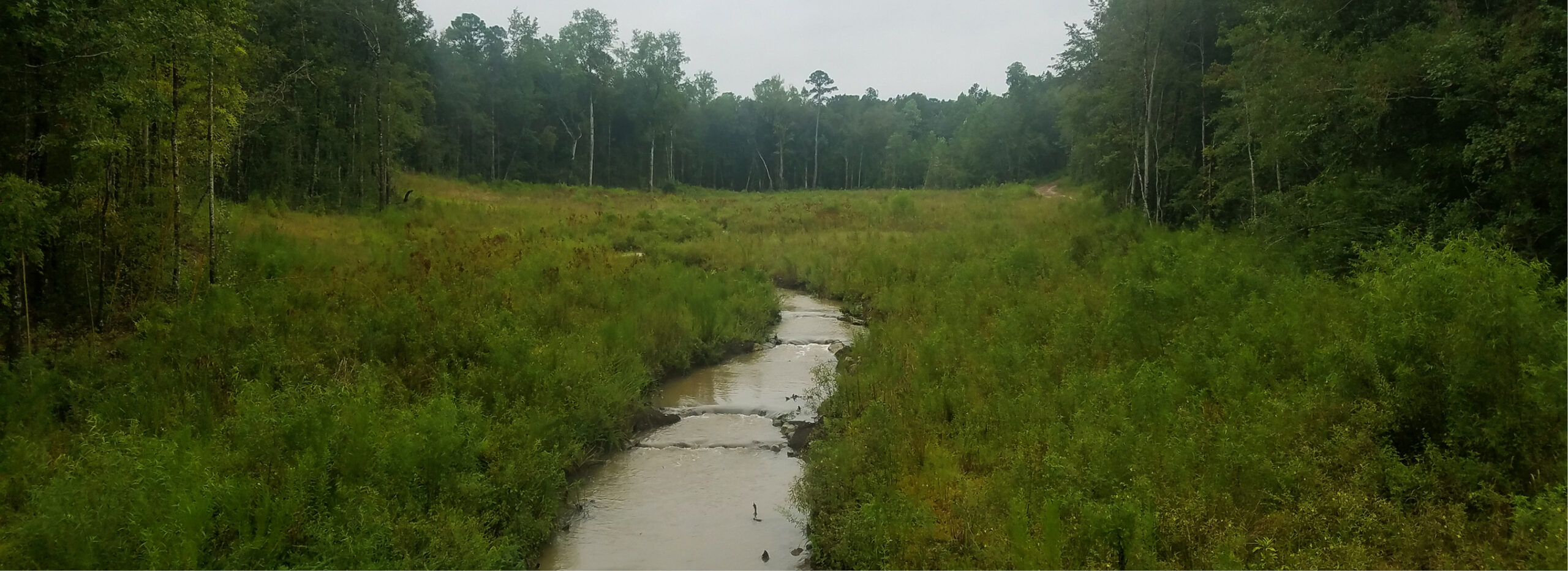
Once a streambed begins to erode, its slope, and in turn the water velocity, increases. This leads to more erosion, cutting of a deeper, narrower channel, and severe streambank erosion, also called “head-cutting.” In contrast, a healthy stream has a shallow channel that floods easily. When a healthy stream exceeds its capacity to carry water flow during a large storm event, it overflows its banks out into its floodplain. Contrary to popular belief, this is a beneficial process. The water slows and its energy is dissipated across the floodplain, and nutrients and sediments are removed from the water and deposited on the floodplain, enhancing in-stream water quality and promoting healthy riparian (streamside) vegetation. The goal in stream restoration, then, is to reconstruct the stream to its proper size, with appropriate dimensions and natural meanders, thereby reconnecting the stream to its natural floodplain. “The key is to have a shallower channel so flooding is a natural event, or a controlled flooding situation,” McLemore said. “Then during heavy rainfall, the energy is dissipated over the floodplain.”
In standard stream restoration practice, a similar stream from the same geographic area, but without the pressures of urban development, is used as a reference to determine appropriate size and shape of a streambed. This “reference reach” serves as a guide to restore the modified and eroded stream to more natural conditions, including physical characteristics such as channel dimensions, stream profile, soil conditions, size of floodplain, and stream pattern (the winding, sinuous channel). The design to restore the impacted stream is therefore “referenced” by the stable stream’s characteristics.
Once stabilized or restored to its natural state, a stream is maintained by natural processes. Sediment transfer is balanced between the stream and floodplain. The stream’s energy is dissipated during flood events, allowing vegetation along the stream to flourish, further stabilizing the streambank and the floodplain and creating additional habitat for wildlife.
In contrast, artificial stormwater infrastructure, such as pipes, culverts, and concrete-lined ditches, must be maintained to keep them functioning and clear of debris.
According to Barrett, “If we can use natural stabilization techniques to put the stream on a path to restore itself, the day we leave the site is the weakest the stream will ever be. It only gets stronger from that point on. If we use concrete to harden the surfaces or line the bank, however, the day we leave the site is the strongest that stream will ever be. It will continue to get weaker over time, requiring continuing maintenance.”
Restoration in the D’Olive Bay Watershed
The MBNEP’s D’Olive watershed management plan identified three streams underlying severe sedimentation in Mobile Bay: D’Olive Creek, Tiawasee Creek and Joe’s Branch. Tiawasee Creek and Joe’s Branch flow into D’Olive Creek, which flows into D’Olive Bay. A 2010 study showed that D’Olive Creek and Tiawasee Creek transported 7,800 tons of sediment downstream per year, representing 14 times the amount expected from a stable, undeveloped area.
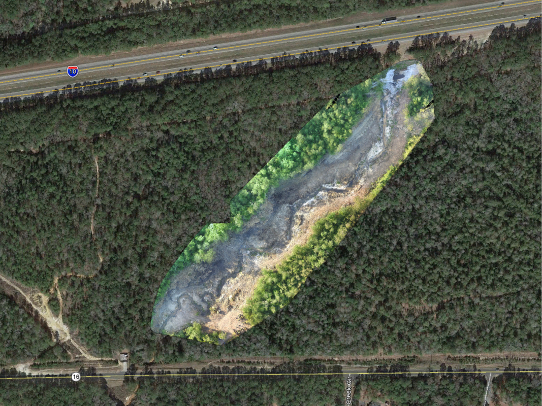
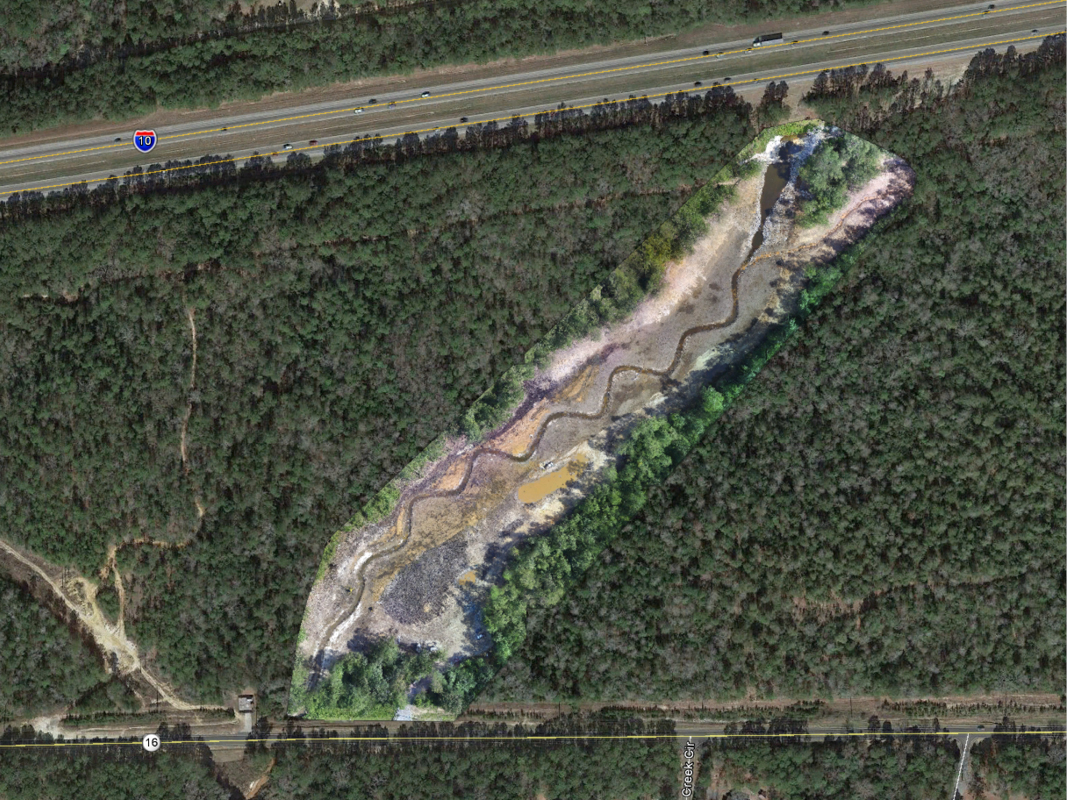
The GMC team was in charge of two projects identified in the watershed management plan and funded by the MBNEP: restoration of 1,400 feet of Tiawasee Creek and 2,236 feet of D’Olive Creek.
The solution to restore the two streams to their natural processes would have been straight forward had it not been for their locations. The streams were positioned in the middle of extensive urban development, including shopping centers, residential neighborhoods, golf courses, an urban roadway network, and an interstate highway. Therefore, completely restoring the streams to their pre-development conditions was not feasible.
The team first used reference data from a minimally-impacted stream and local watershed data to identify natural conditions. Next, they considered stresses being applied to the surrounding floodplain related to its urbanized setting. “The danger is that a natural stream channel designed in a vacuum could potentially be overrun by the stresses presented by an urbanized environment,” McLemore said. “What sort of forces do you have, do you really know and understand your watershed, and have you effectively modeled your system to ensure it won’t be obliterated just by trying to replicate a natural system?”
Concrete culverts had previously been installed at critical points within the watershed, which the project team had to take into consideration during the planning and design process. Restoring a stream requires it be returned to a more stable, natural condition. This usually means adjusting its profile to account for changes that have occurred in the watershed. In these two streams, however, culverts had been installed that established an elevation for the creeks that could not be changed without significant infrastructure modifications that far exceeded the planned budget. “If we had our way, we would raise that elevation, but we couldn’t change the culvert elevation,” Barrett said. “Our slopes are a little bit higher than if we didn’t have that culvert, so we’re using channel design to mimic natural processes in a constrained project area.”
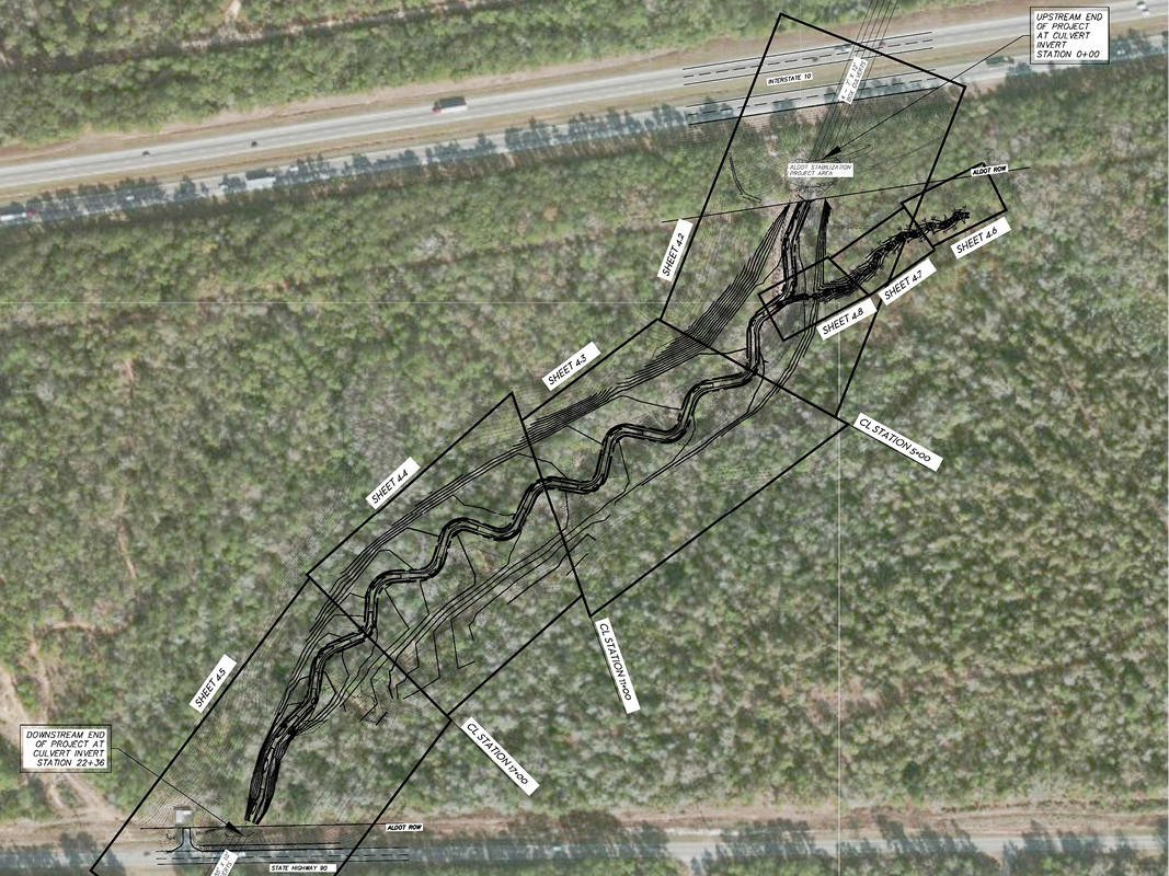
Culverts were located both upstream and downstream of the D’Olive Creek restoration segment. On Tiawasee Creek, a downstream culvert was present that could not be altered, along with a stable wetland just upstream of the restoration segment and a sewer line running parallel to the stream. It was important that none of the planned stream restoration elements were detrimental to the natural wetland, presenting another design constraint for the team to manage.
These two challenging projects were exercises in combining natural stream restoration techniques with sound engineering principles to allow nature to do its job in an area of tremendous urban pressure within the constraints of upstream and downstream stormwater infrastructure. The GMC team developed solutions that allowed the streams to use their floodplains to dissipate energy and naturally deliver sediment in the floodplain.
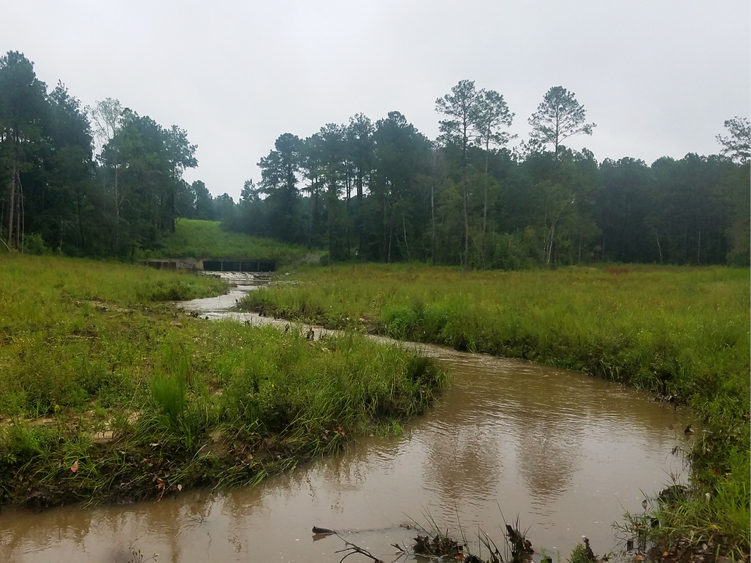
Modifications to Tiawasee Creek
For Tiawasee Creek, GMC’s design set out to stop the head-cutting in a 1,400-foot segment and restore and stabilize the channel through natural channel restoration and best engineering practices. The creek’s eroded condition consisted of multiple threaded streams that converged into a deeply incised creek. The objectives were met through design of a new, relocated stream channel within a wider floodplain at a different elevation, installation of rock and log energy-dissipating structures, and headwater wetland restoration. The design also mitigated sediment deposition downstream and revitalized the wetland complex upstream through channel stabilization and planting of native vegetation.
Modifications to D’Olive Creek, Segments D4-D6
To restore a 2,236-foot section of D’Olive Creek, the project team designed a natural stream and floodplain to handle applied shear stresses of the historical rain event of record to mitigate erosion, improve the riparian community throughout the reach, and maintain the integrity and function of the culverts under Interstate 10. The restoration was achieved through expansion of the floodplain across a nine-acre footprint, stream profile adjustment, and installation of instream energy-dissipating structures. The design also mitigated sediment loading within the project area through channel stabilization and native vegetation installation.
The services the team performed on both streams included watershed assessment, topographic survey, geomorphic survey, conceptual and engineering design, alternatives analysis, hydrologic and hydraulic modeling, construction design, permitting, and cost estimation, in addition to bid document preparation, grant oversight, pre- and post-implementation monitoring, and adaptive management services as the project progressed. Construction management and oversight throughout the entire construction period was provided to ensure the project was completed as designed.
Results
The two stream restorations were completed in 2016. Preliminary studies indicate an estimated 3,240 tons of sediment per year have been prevented from being delivered to Mobile Bay from these restored stream segments. This places the sedimentation delivery rate for the two streams within expected amounts for a natural stream in an undeveloped area.
The projects demonstrate how urban development can coexist with an ecologically-sensitive, biologically-rich estuary by allowing natural stormwater processes to function as intended. With the role the beauty and diversity of Mobile Bay’s ecosystem plays in drawing people to live and work in or to visit the area, it is good to know it can take care of itself—with the help of quality engineering.
About the Experts
William McLemore, PE, LEED Green Associate
William McLemore is an environmental engineer with extensive experience in a variety of project types, including hydrologic and hydraulic modeling and stream restoration using natural channel design. His stream restoration experience includes assessing impacted streams and preparing stream restoration plans utilizing reference stream data, regional curves and regression equations, and hydraulic and hydrologic models, in addition to providing construction oversight and post-construction stream monitoring. William has assisted in securing 319 funding for stream restoration projects in Alabama and has taught workshops as part of the 319 educational component. He graduated from Tulane University with a bachelor’s degree in environmental engineering.
Justin Barrett, PE, CFM
Environmental project manager Justin Barrett has more than six years of experience in stream and wetland delineations, stream and watershed assessment, natural channel design, urban stream stabilization, flood modeling for Letters of Map Change and no-rise certifications, hydrologic assessments, construction management, environmental site assessments, construction stormwater permitting and inspections, erosion control plans and construction best management practices plans. Throughout his career he has had the opportunity to manage ecosystem restoration efforts on a variety of habitats throughout the Southeast. Justin earned a bachelor’s degree in bio-systems engineering from Auburn University. He is a member of the American Society of Agricultural and Biological Engineers, American Ecological Engineering Society and Alabama Association of Floodplain Managers. Justin believes in sharing his knowledge and experience within the industry to develop relationships that will help build a stronger engineering and scientific community.
Goodwyn, Mills and Cawood, Inc.
Goodwyn, Mills and Cawood, Inc. (GMC) is one of the region’s largest privately-held architecture and engineering firms, with more than 375 employees located in offices throughout the southeastern United States. While the company has evolved tremendously since its launch in 1947, our founding principles remain a vital part of our daily operations. We maintain our commitment to keeping client satisfaction, creativity, quality, integrity and diversity as the primary focus of every project. One of the most comprehensive multi-disciplined firms in the Southeast, GMC is equipped to provide all of the services associated with architecture, engineering, environmental, geotechnical, interior design, landscape, planning, surveying and transportation.
Mobile Bay National Estuary Program
The mission of the MBNEP is to promote wise stewardship of the water quality and living resource base of the Mobile Bay estuarine system. The non-regulatory program implements a Comprehensive Conservation Management Plan to conserve the estuary by bringing together citizens; local, state, and federal government agencies; businesses and industries; conservation and environmental organizations; academic institutions; and citizen groups to meet the environmental challenges that face the unique and imperiled resources that characterize coastal estuaries. The MBNEP engages these groups in determining how to best treat the Bay, its associated coastal waters, and the surrounding watersheds to ensure their protection and conservation. www.mobilebaynep.com